UAV & ISR Systems
Unmanned Intelligence, Surveillance & Reconnaissance
Unmanned aerial systems have fundamentally transformed how defense and security organizations gather intelligence, monitor borders, and maintain persistent surveillance over critical areas. SSME provides a portfolio of UAV platforms and ISR payloads engineered for the demanding operational environments found across the Kingdom of Saudi Arabia, the GCC region, and Africa.
Our UAV solutions span fixed-wing platforms for long-endurance, wide-area coverage; vertical takeoff and landing (VTOL) systems for confined-area operations and rapid deployment; and multi-rotor platforms for close-range tactical missions and detailed inspection tasks. Each platform is matched with mission-specific payloads including electro-optical and infrared sensors, multispectral imaging systems, and communication relay modules.
From continuous border surveillance across hundreds of kilometers to rapid-response search and rescue operations, SSME configures each UAV deployment to match the mission profile, terrain conditions, environmental factors, and operational tempo required by the end user. All operations are conducted in compliance with applicable airspace regulations and authorization requirements.
UAV Platform Categories
Three platform categories provide operational flexibility for missions ranging from extended-duration border patrols to short-range tactical reconnaissance.
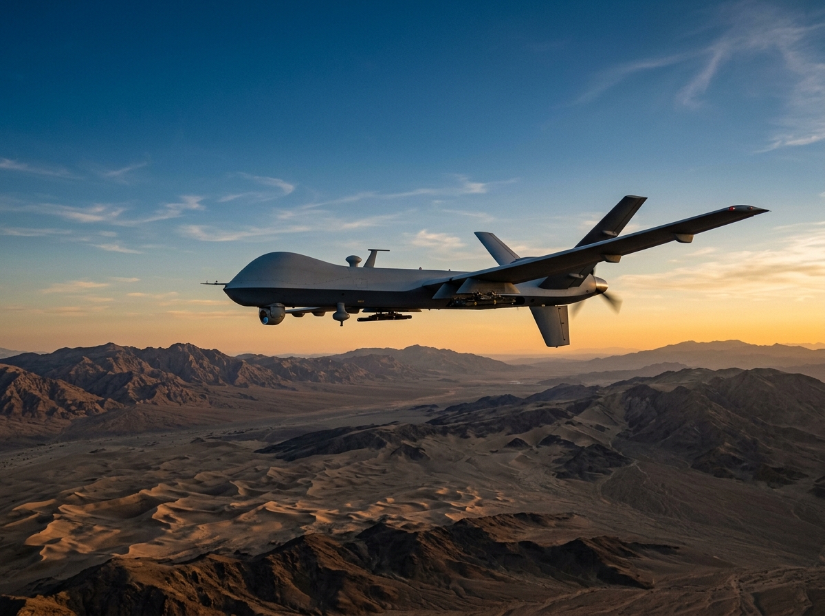
Fixed-Wing UAV
Fixed-wing platforms are designed for long-endurance missions requiring extended flight time and wide-area coverage. These systems are suited for persistent border surveillance, pipeline monitoring, and large-scale area reconnaissance where operational duration and range are primary requirements.
- Extended flight endurance (mission-dependent)
- Wide-area coverage capability
- High-altitude operational ceiling
- Multiple payload configurations
- Runway or catapult launch options
VTOL UAV
Vertical takeoff and landing platforms combine the hover capability of rotary-wing aircraft with the forward-flight efficiency needed for medium-range missions. VTOL systems operate from confined areas without runway infrastructure, making them suitable for rapid deployment to forward positions and urban environments.
- No runway required
- Hover and loiter capability
- Confined-area operations
- Rapid deployment readiness
- Transition flight efficiency
Multi-Rotor UAV
Multi-rotor platforms provide short-range tactical capability for close inspection, perimeter checks, and detailed surveillance of specific areas of interest. These systems are quickly deployable by small teams and offer precise hovering stability for high-resolution imaging and sensor data collection.
- Rapid man-portable deployment
- Precision hover stability
- Close-range inspection capability
- Minimal operator training requirement
- Indoor and confined-space capable
Mission-Configurable Sensor Payloads
Each UAV platform supports a range of interchangeable payloads selected based on mission requirements, operating conditions, and intelligence objectives.
EO/IR Cameras
High-resolution electro-optical and infrared imaging systems providing day and night surveillance capability with zoom, tracking, and geo-referencing functions for target identification at extended ranges.
Multispectral Imaging
Advanced multispectral sensors capture data across multiple wavelength bands, enabling terrain analysis, vegetation assessment, environmental monitoring, and detection of concealed objects or disturbances.
SIGINT-Ready Integration
Platform architecture supports the integration of signals intelligence payloads, subject to applicable regulatory authorization and end-user requirements, for electronic surveillance and spectrum monitoring missions.
Communication Relay
Airborne communication relay modules extend radio and data network coverage to remote areas, forward positions, and terrain-obstructed zones where ground-based communication infrastructure is unavailable or insufficient.
Operational Use Cases
UAV and ISR platforms serve a wide range of defense, security, and civil applications across diverse operational environments.
Border Surveillance
Persistent aerial monitoring of land and maritime borders, detecting unauthorized crossings, smuggling routes, and intrusion attempts across remote and difficult terrain.
Perimeter Monitoring
Scheduled and on-demand aerial patrols of facility perimeters, fence lines, and restricted zones providing a bird's-eye view that complements ground-based security systems.
Search & Rescue
Rapid deployment of UAV platforms with thermal imaging to locate missing persons, stranded assets, or distress situations across desert, coastal, and mountainous terrain.
First Response & Assessment
Immediate aerial assessment of incidents, natural disasters, and security events, providing commanders with real-time visual intelligence before ground teams arrive on scene.
Mapping & Survey
High-resolution aerial mapping, 3D terrain modeling, and photogrammetric surveys for infrastructure planning, route assessment, and operational area analysis.
Reconnaissance
Tactical and strategic aerial reconnaissance missions providing intelligence on areas of interest, route clearance verification, and pre-operational environment assessment.
Understanding UAV & ISR
What is ISR?
ISR stands for Intelligence, Surveillance, and Reconnaissance. It is a coordinated operational function that integrates sensors, platforms, and data processing to collect, analyze, and disseminate actionable information about areas of interest, threats, and operational environments. ISR provides commanders and security operators with the situational awareness needed to make informed decisions. In the context of unmanned systems, ISR refers to using UAV platforms equipped with specialized sensors to gather visual, electronic, and geospatial intelligence from the air without placing personnel at risk.
What is UAV-based surveillance?
UAV-based surveillance uses unmanned aerial vehicles equipped with cameras, sensors, and data links to monitor areas from the air. Unlike manned aircraft, UAVs can operate for extended periods at a fraction of the cost, cover remote or dangerous terrain without risk to crews, and deploy rapidly from forward positions without runway infrastructure. SSME provides UAV-based surveillance solutions for border monitoring, facility protection, event security, and strategic reconnaissance across KSA, GCC, and Africa. All UAV operations are conducted in compliance with applicable airspace regulations and operational authorization requirements.
UAV & ISR Systems FAQ
What is ISR?
ISR — Intelligence, Surveillance, and Reconnaissance — is the integrated collection, processing, and dissemination of actionable information gathered through sensors and observation platforms. In defense and security operations, ISR provides the situational awareness that commanders need to understand their operational environment, detect threats, and make informed decisions. SSME delivers ISR capability through unmanned aerial platforms equipped with electro-optical, infrared, and multispectral sensors that collect intelligence without exposing personnel to risk.
What types of UAVs does SSME offer?
SSME provides three categories of unmanned aerial platforms. Fixed-wing UAVs deliver long-endurance, wide-area coverage for missions such as border surveillance and pipeline monitoring. VTOL (Vertical Takeoff and Landing) platforms combine hover capability with efficient forward flight, operating from confined areas without runway infrastructure. Multi-rotor UAVs offer short-range tactical capability for close inspection, perimeter checks, and rapid deployment by small teams. The specific platform recommendation is based on mission requirements, terrain, endurance needs, and payload specifications.
How long can UAV platforms operate?
Flight endurance is mission-dependent and varies by platform type, payload configuration, altitude, and environmental conditions. Fixed-wing platforms generally offer the longest endurance, suited for persistent surveillance over extended durations. VTOL platforms provide moderate endurance with the advantage of no runway requirement. Multi-rotor platforms offer shorter flight times but compensate with rapid deployment, precision hover, and operational simplicity. SSME works with each client to match the platform endurance profile to the specific mission requirements and operational tempo.
What payloads are available?
SSME UAV platforms support a range of interchangeable payloads selected based on mission objectives. Standard options include high-resolution electro-optical and infrared (EO/IR) camera systems for day and night imaging, multispectral sensors for terrain and environmental analysis, and communication relay modules for extending network coverage. Additional payload integrations are configurable based on specific operational requirements and are subject to applicable regulatory approvals and end-user authorization.
How does mission planning work?
Mission planning begins with a thorough analysis of operational objectives, area of interest, threat environment, terrain conditions, and airspace regulations. SSME mission planners define flight routes, sensor activation sequences, communication link parameters, and contingency procedures. The mission plan is loaded into the ground control station, where operators can monitor execution in real time, adjust parameters as needed, and manage the full flight cycle from launch through recovery. Post-mission, all collected data is processed, analyzed, and delivered through secure reporting channels.
Discuss Your ISR Requirements
Whether you need persistent border surveillance, rapid-response aerial reconnaissance, or a comprehensive UAV program for ongoing operations, our team will assess your mission profile and recommend the right platform and sensor configuration.