Strategic Importance of Red Sea and Arabian Gulf Maritime Corridors
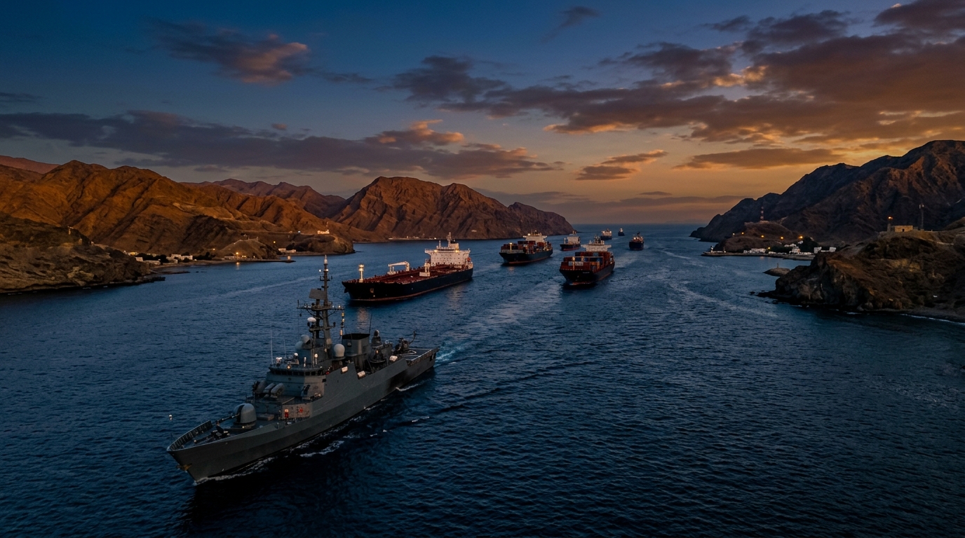
The waters surrounding the Arabian Peninsula rank among the most strategically significant maritime zones on the planet. The Red Sea, connecting the Suez Canal to the Indian Ocean through the Bab el-Mandeb strait, carries an estimated twelve to fifteen percent of global seaborne trade. The Arabian Gulf, linked to the open ocean through the Strait of Hormuz, serves as the transit corridor for approximately one-fifth of the world's petroleum consumption. Together, these waterways form the economic lifeline of the Gulf Cooperation Council states and a critical artery for international commerce.
For the Kingdom of Saudi Arabia, maritime security is inseparable from national security. The Kingdom's western coastline extends approximately 1,800 kilometers along the Red Sea, while its eastern coast faces the Arabian Gulf across nearly 560 kilometers. Major commercial ports, desalination plants that produce a significant share of the nation's drinking water, offshore energy infrastructure, and naval installations line both coasts. Any disruption to maritime operations in either corridor threatens not only Saudi economic interests but the stability of global energy markets and international trade flows.
The convergence of commercial shipping density, critical infrastructure exposure, and evolving threat actors creates a maritime security environment of exceptional complexity. Defense forces responsible for securing these waters must contend with traditional naval threats, asymmetric tactics, and emerging technologies that challenge conventional approaches to maritime domain awareness and force protection.
The Maritime Threat Landscape
The threat vectors affecting Red Sea and Arabian Gulf maritime operations have diversified significantly in recent years. While traditional concerns such as piracy and smuggling persist, the theater has seen the emergence of sophisticated asymmetric capabilities that pose qualitatively different challenges to naval and coast guard forces.
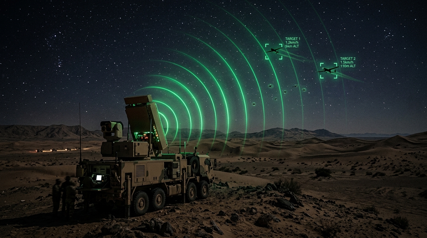
Unmanned aerial threats have emerged as a persistent concern in the maritime domain. Small unmanned aerial systems can be launched from coastal positions or vessels to conduct reconnaissance, deliver payloads, or overwhelm defensive systems through swarming tactics. These platforms are inexpensive, difficult to detect at range against sea clutter, and can be operated by non-state actors with minimal training. The application of counter-UAS technologies to the maritime environment presents unique challenges compared to land-based deployments, including the effects of salt spray on sensors, the difficulty of maintaining radar coverage across vast open-water areas, and the legal complexities of engagement in international waters.
Explosive-laden unmanned surface vessels represent another asymmetric threat that has been demonstrated operationally in the region. These remotely piloted or autonomously guided craft can approach commercial vessels or naval assets at high speed, making them difficult to detect and engage in time. Defending against unmanned surface threats requires a combination of radar surveillance, electro-optical tracking, and rapid-engagement weapon systems integrated into a responsive command and control architecture.
Sea mine threats remain a persistent concern, particularly in chokepoints where shipping is constrained to narrow navigable channels. The Bab el-Mandeb strait and the approaches to major ports are areas where even crude mine devices can cause disproportionate disruption to maritime traffic. Mine countermeasures require specialized vessels, underwater detection systems, and sustained sweep operations that tie down significant naval resources.
Smuggling and illicit trafficking continue to exploit the vast maritime space, using fast boats, dhows, and commercial vessel concealment to move contraband, weapons, and personnel across maritime boundaries. Countering these activities requires persistent surveillance, pattern-of-life analysis, and the ability to conduct vessel boarding and inspection operations across dispersed areas of operation.
Maritime Domain Awareness: Seeing the Full Picture
Effective maritime security begins with comprehensive maritime domain awareness, the ability to know what is happening across the maritime environment at all times. This encompasses the identification, tracking, and classification of every vessel, aircraft, and activity within waters of interest. Achieving this level of awareness across the vast expanses of the Red Sea and Arabian Gulf requires the integration of multiple surveillance technologies into a coherent monitoring architecture.
Automatic Identification System tracking provides the foundation of cooperative maritime surveillance. Commercial vessels above a certain tonnage are required to broadcast AIS signals that report their identity, position, course, and speed. Shore-based AIS receivers, satellite-based AIS collection, and vessel-mounted AIS transceivers create a comprehensive picture of cooperative maritime traffic. However, AIS is a self-reporting system that can be spoofed, disabled, or simply switched off by vessels seeking to evade detection. Therefore, AIS data must be cross-referenced with non-cooperative surveillance sources.
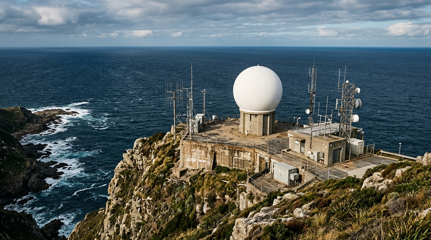
Coastal radar networks provide non-cooperative detection of surface vessels within their coverage area, typically extending forty to sixty nautical miles from shore depending on antenna height and atmospheric conditions. Modern coastal surveillance radars can detect small craft, classify targets by their radar cross-section and movement patterns, and automatically alert operators to anomalous behavior. Integrating multiple coastal radar sites into a unified surveillance network creates overlapping coverage along critical coastlines and approaches to ports.
Satellite surveillance extends maritime domain awareness beyond the reach of shore-based sensors. Synthetic aperture radar satellites can detect vessels on the open ocean regardless of weather or time of day. Optical surveillance satellites provide high-resolution imagery for vessel identification and port monitoring. The combination of satellite and shore-based surveillance enables maritime security forces to maintain awareness across the full extent of their waters of interest.
Airborne surveillance using manned maritime patrol aircraft and unmanned aerial systems provides the flexibility to investigate contacts of interest, maintain surveillance on specific vessels, and extend coverage to areas beyond shore-based radar range. Maritime patrol aircraft equipped with surface search radar, electro-optical and infrared sensors, and electronic surveillance measures can classify vessels, detect anomalous activity, and provide real-time intelligence to maritime command centers.
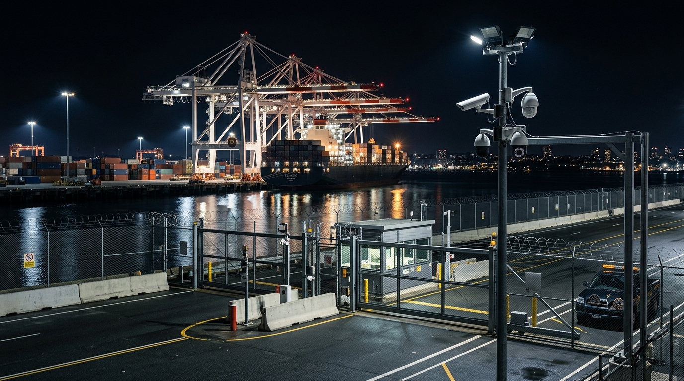
Port Security: Defending Maritime Infrastructure
Ports represent the critical nodes where maritime and land-based transportation networks converge. They are high-value targets that concentrate commercial activity, energy infrastructure, and in many cases naval assets within defined geographic perimeters. Port security encompasses physical perimeter defense, waterside surveillance, underwater detection, cargo screening, and vessel traffic management.
The waterside perimeter of a port is inherently more difficult to secure than its landside boundary. Small craft can approach from any direction, divers can penetrate underwater, and the constant flow of commercial vessel traffic creates a complex environment where threat activity can be concealed within legitimate operations. Addressing waterside security requires an integrated approach that combines surface surveillance radar, underwater sonar and diver detection systems, electro-optical cameras with automated tracking, and rapid-response boat teams.
Cargo screening represents another critical dimension of port security. The volume of containerized cargo transiting major ports makes one-hundred-percent physical inspection impractical. Risk-based screening approaches use advance cargo information, intelligence assessments, and non-intrusive inspection technologies such as X-ray and gamma-ray scanners to identify high-risk shipments for detailed inspection while allowing the flow of legitimate commerce to continue with minimal delay.
Vessel traffic management systems coordinate the movement of ships within port approaches and harbor areas, reducing the risk of collision, grounding, and unauthorized entry. These systems integrate AIS data, radar tracking, VHF communications, and pilot scheduling into a unified traffic management picture that enables port authorities to maintain safe and efficient vessel movements.
Naval Patrol and Interdiction Operations
Maritime security is ultimately enforced at sea by naval and coast guard vessels conducting patrol, surveillance, and interdiction operations. The operational demands placed on these forces in the Red Sea and Arabian Gulf are substantial, requiring persistent presence across vast areas, the ability to respond rapidly to emerging threats, and the capacity to conduct the full spectrum of maritime operations from routine inspections to combat engagements.
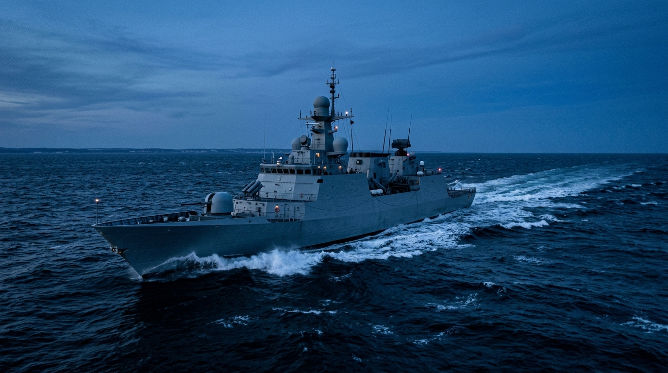
Surface patrol operations require a mix of vessel types optimized for different roles. Large patrol vessels and corvettes provide extended endurance and can operate in higher sea states, making them suitable for offshore patrol and escort missions. Fast interceptor craft provide the speed needed to pursue and intercept small, high-speed threats in coastal waters. Specialized mine countermeasures vessels conduct survey and clearance operations in critical waterways. The optimal force mix depends on the specific threat environment, operational area, and mission priorities of each maritime security force.
Aerial reconnaissance complements surface patrol by providing wide-area coverage that individual vessels cannot achieve. Maritime patrol aircraft and unmanned aerial systems can survey hundreds of square nautical miles per sortie, cueing surface forces to investigate contacts of interest. The integration of airborne and surface surveillance into a common tactical picture enables more efficient allocation of patrol resources and faster response to detected threats.
Coordination between naval forces, coast guard organizations, port authorities, and allied maritime partners is essential for effective maritime security. Information sharing agreements, combined patrol protocols, and interoperable communication systems enable the different organizations responsible for maritime security to operate as a cohesive whole rather than as isolated entities with gaps between their areas of responsibility.
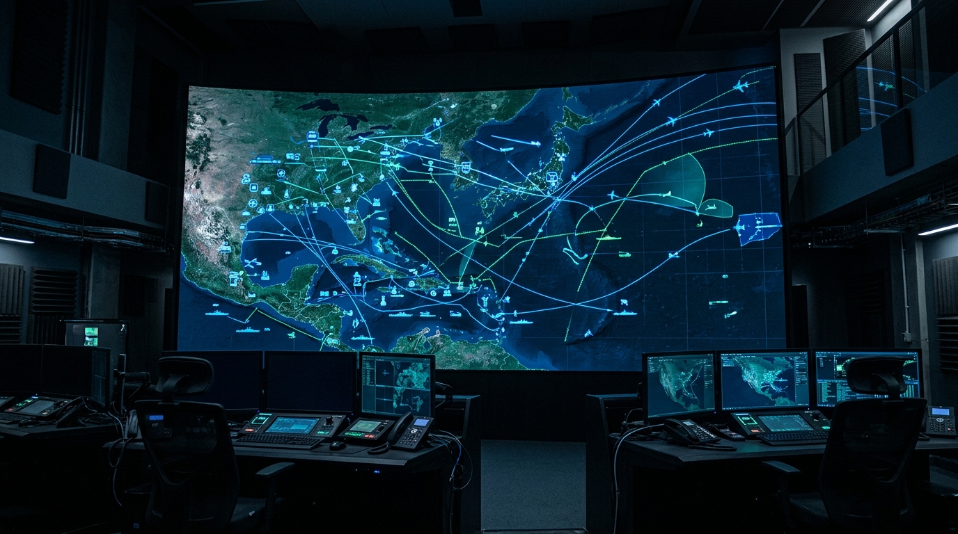
Coastal Surveillance and Integrated Maritime C2
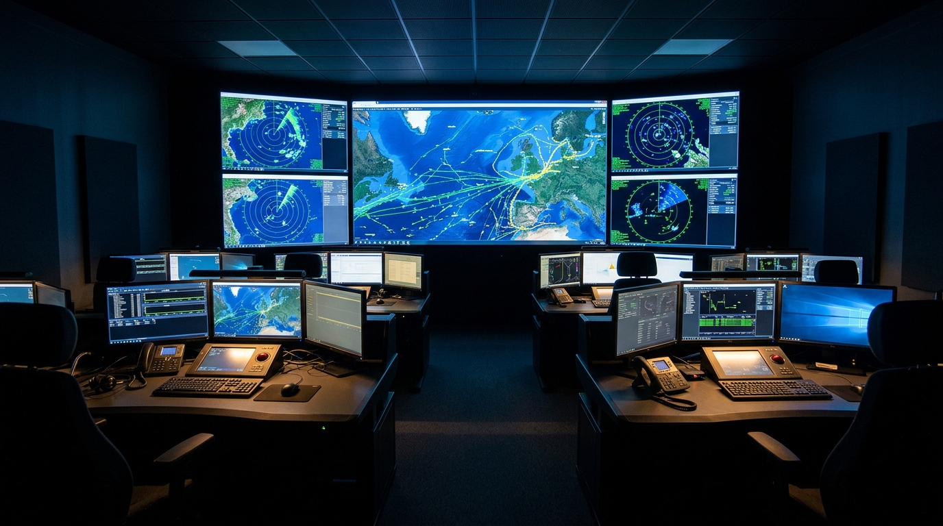
The integration of all maritime surveillance sources into a unified command and control architecture is the cornerstone of effective maritime security. Maritime operations centers serve as the central nodes where sensor data is fused, situations are assessed, decisions are made, and forces are directed. These centers receive inputs from coastal radar sites, AIS networks, satellite surveillance systems, maritime patrol aircraft, naval vessels, and intelligence sources, presenting the combined picture on large-format tactical displays.
Land-based coastal surveillance stations form the permanent infrastructure of the maritime surveillance network. A typical coastal surveillance station integrates a surface search radar, electro-optical and infrared cameras with long-range zoom capability, an AIS receiver, a meteorological sensor, and communications equipment within a hardened shelter. These stations operate continuously, providing twenty-four-hour surveillance coverage of their assigned coastal sector. The data from each station is transmitted to the maritime operations center, where it is fused with data from other sources to create the comprehensive maritime picture.
Modern maritime C2 systems employ automated alerting and anomaly detection algorithms that reduce operator workload and improve response times. These algorithms can detect vessels deviating from established shipping lanes, vessels approaching restricted areas, vessels exhibiting erratic behavior, vessels operating without AIS, and other indicators of potential security concern. Automated alerts direct operator attention to situations that require assessment and decision, rather than requiring operators to continuously scan the entire tactical picture for anomalies.
Technology Trends: The Future of Maritime Security
Several technology trends are reshaping the capabilities available to maritime security forces. Autonomous surface vessels offer the potential for persistent surveillance and patrol presence without the cost and crew requirements of manned platforms. These unmanned vessels can be deployed to maintain station in areas of interest for extended periods, reporting surveillance data to command centers and alerting manned forces when investigation or interdiction is required.
Maritime unmanned aerial systems designed specifically for the maritime environment are extending the reach and persistence of airborne surveillance. Ship-launched and shore-launched maritime UAV platforms can conduct surveillance sorties lasting many hours, providing real-time electro-optical and radar imagery of surface activity across wide areas. The integration of these platforms into the maritime C2 architecture enables more responsive and cost-effective surveillance coverage compared to manned aircraft alone.
Artificial intelligence and machine learning are being applied to maritime domain awareness to automate vessel classification, detect anomalous behavior patterns, predict vessel movements, and reduce the volume of data that human operators must process. AI-based pattern detection can identify subtle indicators of illicit activity, such as vessel rendezvous patterns consistent with at-sea transfer operations, that would be extremely difficult for human analysts to detect across the enormous data volumes generated by modern maritime surveillance systems.
Underwater domain awareness is an emerging priority as subsurface threats and underwater infrastructure become increasingly important. Sonar networks, autonomous underwater vehicles, and seabed sensor arrays extend maritime domain awareness below the surface, addressing threats from divers, submarines, underwater drones, and sea mines that surface surveillance systems cannot detect.
Regional Context: Securing Strategic Chokepoints
The geopolitical context of Red Sea and Arabian Gulf maritime security cannot be separated from the geography of two critical chokepoints. The Bab el-Mandeb strait, approximately thirty kilometers wide at its narrowest point, controls access between the Red Sea and the Gulf of Aden. The Strait of Hormuz, approximately thirty-nine kilometers wide with navigable channels of just six kilometers, controls access between the Arabian Gulf and the Gulf of Oman.
These chokepoints create natural concentration points for both commercial traffic and security threats. The narrow geographic constraints limit vessels' ability to maneuver and avoid threats, while the high density of traffic creates a complex environment where hostile activity can be concealed among legitimate shipping. Securing these chokepoints requires layered surveillance architectures, rapid-response forces positioned within engagement range, and close coordination with neighboring states that share responsibility for the waterways.
Saudi Arabia's geographic position, with coastlines on both the Red Sea and the Arabian Gulf, places the Kingdom at the nexus of both chokepoint security challenges. The Kingdom's maritime security forces must maintain surveillance and response capabilities across both theaters simultaneously, requiring significant investment in sensors, platforms, communications infrastructure, and trained personnel. The integration of these capabilities under a unified maritime command and control architecture is essential for ensuring that the Kingdom can protect its maritime interests, defend its coastal infrastructure, and contribute to the security of the international waterways that are vital to global commerce.
Securing Vital Maritime Trade Routes
The security of Red Sea and Arabian Gulf maritime corridors is a shared responsibility that extends beyond any single nation. Regional cooperation through organizations such as the GCC, combined naval task forces, and bilateral security agreements provides the framework for collaborative maritime security operations. Information sharing between regional navies, coordinated patrol schedules, and joint exercise programs build the interoperability and mutual trust required for effective combined maritime operations.
The technological dimension of maritime security continues to evolve rapidly. New sensor technologies extend detection ranges and improve classification accuracy. Autonomous platforms increase surveillance persistence and reduce the burden on manned forces. Artificial intelligence accelerates the processing of surveillance data and the detection of anomalous activity. Integrated command and control architectures fuse these capabilities into coherent operational pictures that enable timely and informed decision-making.
For defense decision-makers in Saudi Arabia and across the GCC, the maritime security investment case is clear. The economic value of the maritime trade flowing through regional waters, the strategic importance of energy infrastructure along both coasts, and the evolving nature of maritime threats all demand sustained commitment to maritime domain awareness, force modernization, and regional cooperation. The security of the seas is, in a very direct sense, the security of the region's prosperity and stability.