The Scale of Desert Border Surveillance
The Kingdom of Saudi Arabia shares more than 6,700 kilometers of land borders with seven neighboring countries, spanning terrain that ranges from the vast Rub' al Khali sand sea in the south to the rocky desert plateaus of the northern frontier. Across the broader GCC and into the African continent, nations confront similar challenges: enormous border distances crossing some of the most inhospitable terrain on Earth, where temperatures regularly exceed 50 degrees Celsius, infrastructure is sparse or nonexistent, and human patrols can cover only a fraction of the total perimeter.
Traditional border security approaches that rely primarily on fixed infrastructure and manned observation posts are fundamentally inadequate for these environments. The distances involved make continuous physical barriers impractical across every kilometer. The extreme climate limits the duration and effectiveness of foot and vehicle patrols. And the featureless terrain of many desert regions offers intruders natural concealment through the simple absence of observation points. The result is a persistent surveillance gap that adversaries can exploit for illicit border crossing, smuggling operations, and unauthorized territorial incursion.
Addressing this gap requires a technology-driven approach that combines multiple sensor modalities, autonomous platforms, and networked communications to create persistent awareness across vast frontier distances. The technologies and architectures discussed in this analysis represent the current state of the art in arid-environment border surveillance, drawing on operational experience from deployments across the Middle East and Africa.
Environmental Challenges: The Desert Factor
Before examining specific technologies, it is essential to understand the environmental conditions that make desert border surveillance fundamentally different from operations in temperate or maritime settings. These conditions do not merely reduce performance; they can render entire categories of equipment ineffective if not properly accounted for in system design and deployment planning.
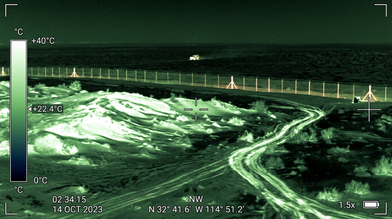
Extreme heat and thermal dynamics create multiple challenges simultaneously. Daytime ground surface temperatures in Arabian and Saharan deserts can exceed 70 degrees Celsius, generating severe thermal stress on electronic components, batteries, and optical systems. Equally important, the extreme daytime heat reduces the thermal contrast between human targets and their surroundings, degrading the detection range of thermal imaging systems during peak afternoon hours. Conversely, the rapid radiative cooling of desert surfaces after sunset creates excellent thermal contrast conditions at night, making the post-dusk and pre-dawn periods the most effective windows for infrared surveillance. Understanding this thermal cycle is critical for planning sensor coverage and patrol schedules.
Sand and dust interference affects virtually every sensor category. Fine particulate matter abraded from sandstone and carried by wind scours optical surfaces, infiltrates mechanical assemblies, and deposits conductive films on electronic contacts. Shamal wind events can reduce visibility to near zero and deposit centimeters of accumulated dust on exposed equipment within hours. Any sensor system intended for sustained desert deployment must incorporate hardened enclosures rated to IP65 or higher, automated wiper or air-blast cleaning systems for optical elements, and filtered positive-pressure ventilation for electronics compartments.
Mirage and atmospheric refraction effects are a specific concern for radar and long-range optical systems. Temperature inversions near the desert surface create refractive layers that can bend radar beams and distort optical images, producing false targets, range errors, and bearing inaccuracies. These effects are most pronounced during midday when temperature gradients between the hot surface and the cooler air above are steepest. Radar systems must employ clutter mapping and adaptive thresholding to mitigate surface refraction effects, while optical systems benefit from elevated mounting positions that look above the worst refraction layers.
Limited infrastructure is the overarching constraint. Desert border regions typically lack paved roads, electrical power grids, telecommunications networks, and potable water supplies. Every piece of surveillance equipment must either be self-sufficient in terms of power and communications or be supported by dedicated infrastructure that is itself designed for desert resilience. This constraint fundamentally shapes system architecture, favoring solar-powered sensors, satellite communications, and platforms designed for minimal maintenance intervals.

Sensor Technologies for Arid-Zone Surveillance
Effective desert border surveillance relies on the complementary deployment of multiple sensor technologies, each contributing specific detection capabilities that together create a comprehensive awareness picture. The selection and configuration of these sensors must be optimized for the specific environmental conditions discussed above.
Thermal and Infrared Imaging
Thermal infrared sensors are arguably the most valuable single technology for desert border surveillance. During the critical nighttime hours when most illicit border crossing activity occurs, cooled thermal cameras can detect the heat signatures of personnel and vehicles at ranges exceeding 10 kilometers under favorable atmospheric conditions. The thermal contrast between a human body at approximately 37 degrees Celsius and the rapidly cooling desert surface after sunset creates ideal detection conditions that no other passive sensor can match.
Modern long-range thermal imaging systems employ cooled mercury cadmium telluride or indium antimonide detector arrays operating in the mid-wave infrared band, which offers the best atmospheric transmission characteristics in dry desert air. These systems can be mounted on elevated mast structures to maximize their line-of-sight coverage and minimize the impact of near-surface atmospheric distortion. Continuous pan-tilt scanning enables a single thermal sensor to monitor a wide sector, with automated detection algorithms flagging thermal anomalies that may indicate human or vehicle presence for operator review.
During daytime hours, when thermal contrast is reduced, shortwave infrared and visible-spectrum cameras supplement the thermal capability. High-definition daylight cameras with powerful zoom optics can provide detailed imagery for target classification and identification at long range, while shortwave infrared sensors can penetrate light haze and dust that would degrade visible-spectrum performance.
Radar-Based Ground Surveillance
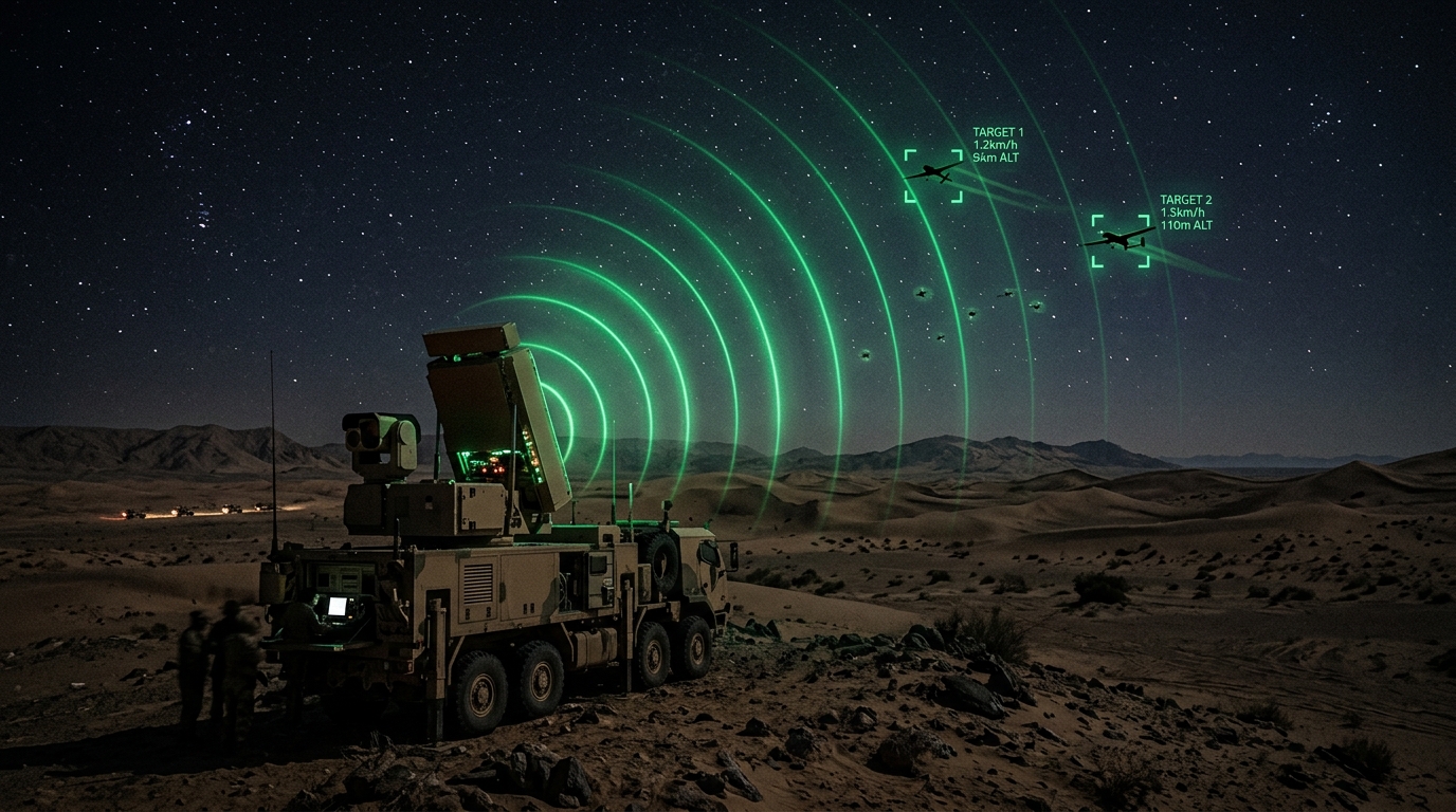
Ground surveillance radar complements thermal imaging by providing all-weather, day-and-night detection capability that is less affected by atmospheric conditions. Unlike air surveillance radars designed to track aircraft, ground surveillance radars are optimized to detect the slow-moving, low-reflectivity targets characteristic of border intrusion scenarios: individuals on foot, small vehicles, and animal traffic.
Modern ground surveillance radars employ frequency-modulated continuous wave or pulse-Doppler techniques to detect and track moving targets while suppressing returns from stationary ground clutter. Detection ranges for personnel targets typically extend from 5 to 20 kilometers depending on terrain, target motion characteristics, and radar configuration. These systems excel at providing early warning of approaching targets at ranges where thermal cameras may not yet have sufficient resolution for detection, effectively serving as a wide-area alerting layer that cues more precise sensors.
One significant advantage of radar in desert environments is its relative immunity to the sand and dust conditions that challenge optical sensors. While extreme sand storms can introduce radar clutter and attenuate signals, radar maintains useful detection capability in conditions that would render cameras blind. This all-weather resilience makes radar an essential component of any surveillance architecture that must deliver persistent coverage regardless of environmental conditions.
Seismic and Acoustic Sensors
Buried seismic sensors and surface-mounted acoustic arrays provide a covert detection layer that is invisible to approaching intruders and resistant to most forms of environmental interference. Seismic sensors detect ground vibrations produced by footsteps, vehicle traffic, and digging activity, classifying these vibrations by signature to distinguish between personnel, light vehicles, heavy vehicles, and animals. When properly calibrated for local soil conditions, seismic sensors can detect foot traffic at ranges of several hundred meters and vehicle traffic at ranges exceeding one kilometer.
Acoustic sensors detect airborne sound from the same categories of activity, with particular effectiveness in the quiet desert environment where ambient noise levels are typically very low. The combination of seismic and acoustic detection provides high-confidence alerting with very low false-alarm rates, as the correlation of simultaneous seismic and acoustic signatures substantially reduces the probability of false triggers from natural phenomena such as animal movement or wind effects.
UAV-Based Border Patrols
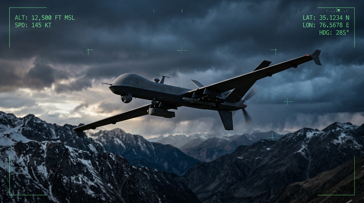
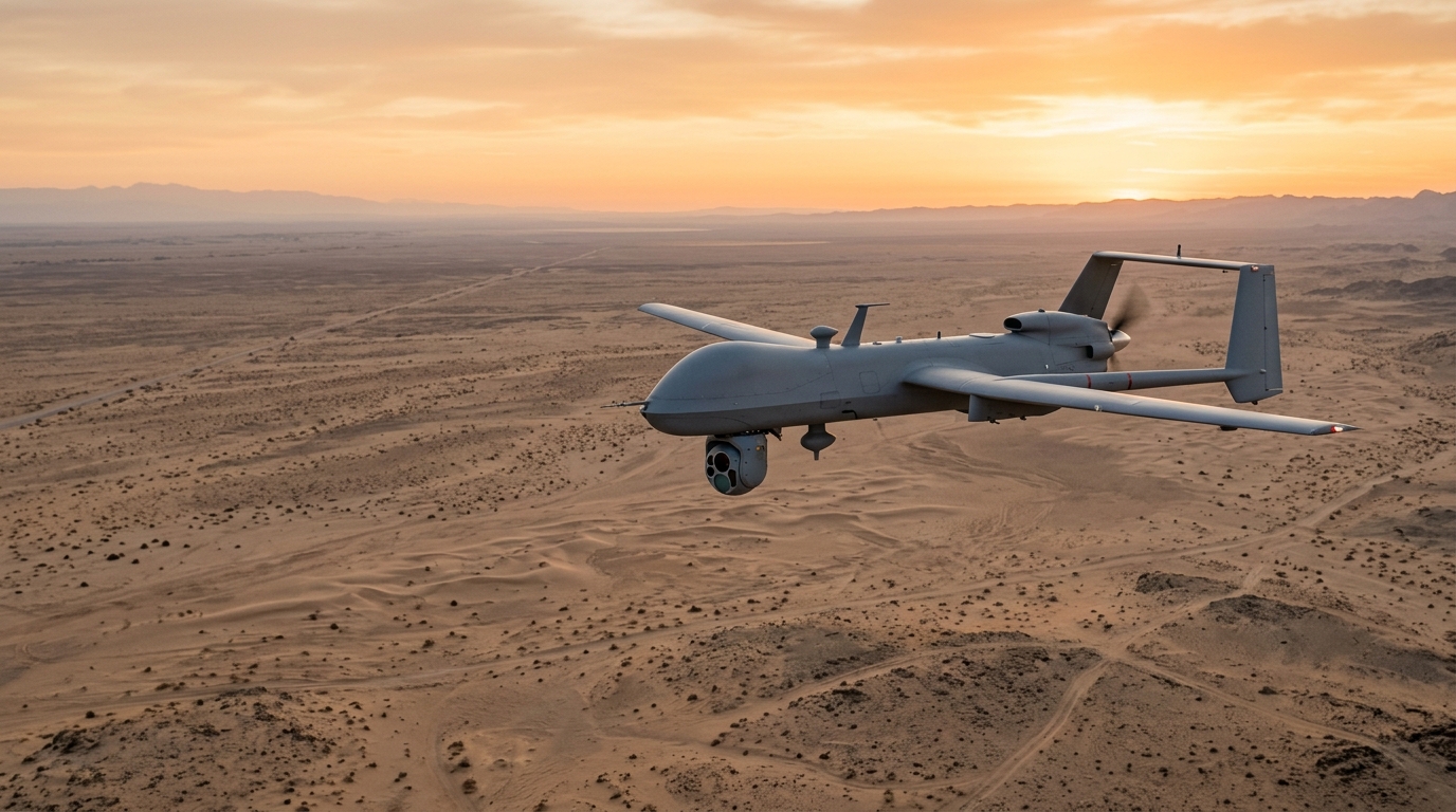
Unmanned aerial vehicles have transformed border surveillance by providing a persistent aerial observation capability that can cover hundreds of kilometers of frontier in a single mission. Fixed-wing UAV platforms designed for long-endurance operations can remain airborne for 12 to 24 hours or more, carrying thermal and daylight camera payloads that survey the border corridor from altitudes that provide broad area coverage while maintaining sufficient resolution for target detection and classification.
Operating UAVs over featureless desert terrain introduces specific challenges that differ from operations over varied landscapes. The absence of visual landmarks complicates navigation for manually piloted systems, making GPS-based autonomous flight planning essential. Thermal updrafts from the desert surface during daytime hours create turbulence that affects platform stability and sensor image quality, requiring either higher operating altitudes or stabilization systems designed for these conditions. Sand and dust at low altitudes can damage engine intake systems and abrade optical surfaces on sensor payloads, necessitating hardened air filtration and protective lens covers.
Real-time video relay from airborne UAVs to ground command centers requires robust data links that maintain connectivity over the extended ranges typical of border operations. Beyond-line-of-sight communications via satellite relay enable UAV operations across the full depth of the border zone without the range limitations of direct radio links. This capability allows a single ground control station to manage UAV patrols covering hundreds of kilometers of frontier, directing sensors to areas of interest identified by ground-based detection systems or intelligence inputs.
The integration of UAV patrols with ground-based sensor networks creates a responsive surveillance architecture in which stationary sensors provide continuous wide-area monitoring while UAVs deliver rapid, on-demand close investigation of detected activities. When a ground sensor registers a potential intrusion, a UAV can be redirected to overfly the location within minutes, providing the high-resolution imagery needed for assessment and response decisions.
Ground Sensor Networks: Unattended Persistence
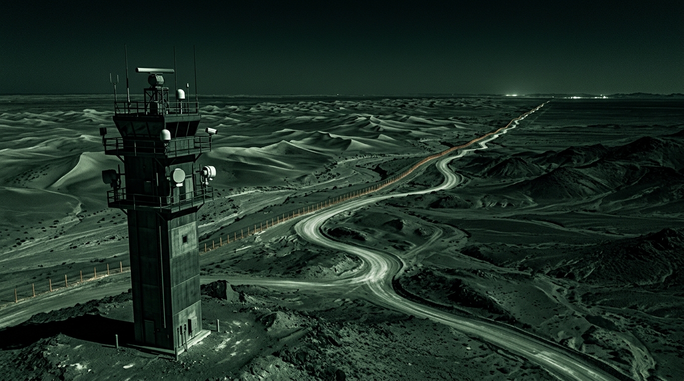
The backbone of any desert border surveillance system is a distributed network of unattended ground sensors positioned along the frontier to provide continuous detection coverage. These sensors operate autonomously for extended periods, reporting detections via wireless communication links to regional monitoring centers without requiring permanent manning at each sensor location.
Solar-powered relay stations form the communications backbone of ground sensor networks in regions without electrical grid access. These installations combine photovoltaic panels with battery storage to provide continuous power for communications relay equipment, typically operating in the VHF, UHF, or microwave frequency bands depending on the required range and data throughput. In desert environments, solar power generation is highly reliable due to the consistently high levels of solar irradiance, though panel surfaces must be regularly cleaned to remove accumulated dust that reduces generation efficiency.
Mesh communication architectures are preferred over hub-and-spoke topologies for desert sensor networks because they provide inherent redundancy. If any single relay node fails or is damaged, sensor data can be routed through alternative paths in the mesh, maintaining network connectivity without single points of failure. This resilience is critical in remote desert environments where maintenance response times may be measured in days rather than hours.
The placement of ground sensors along a desert border follows principles derived from the detection capabilities of each sensor type and the terrain characteristics of the specific border segment. Seismic and acoustic sensors are positioned at close intervals in areas where terrain channeling concentrates likely crossing routes, such as wadis, gaps between dune ridges, and areas near roads or tracks. Radar and thermal sensors are positioned on elevated terrain features or purpose-built towers to maximize their line-of-sight coverage across open desert flats. The resulting sensor layout provides layered detection coverage that maximizes the probability of detecting any crossing activity while minimizing the total number of sensor installations required.
Mobile Command Integration
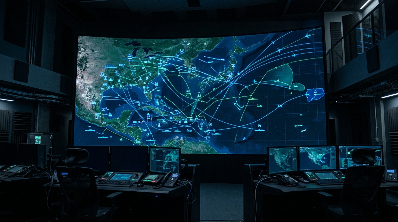
Fixed command centers serve as the primary hubs for processing and analyzing border surveillance data, but the dynamic nature of border security operations demands mobile command capability that can deploy forward to manage specific incidents or reinforce surveillance coverage in areas of heightened activity.
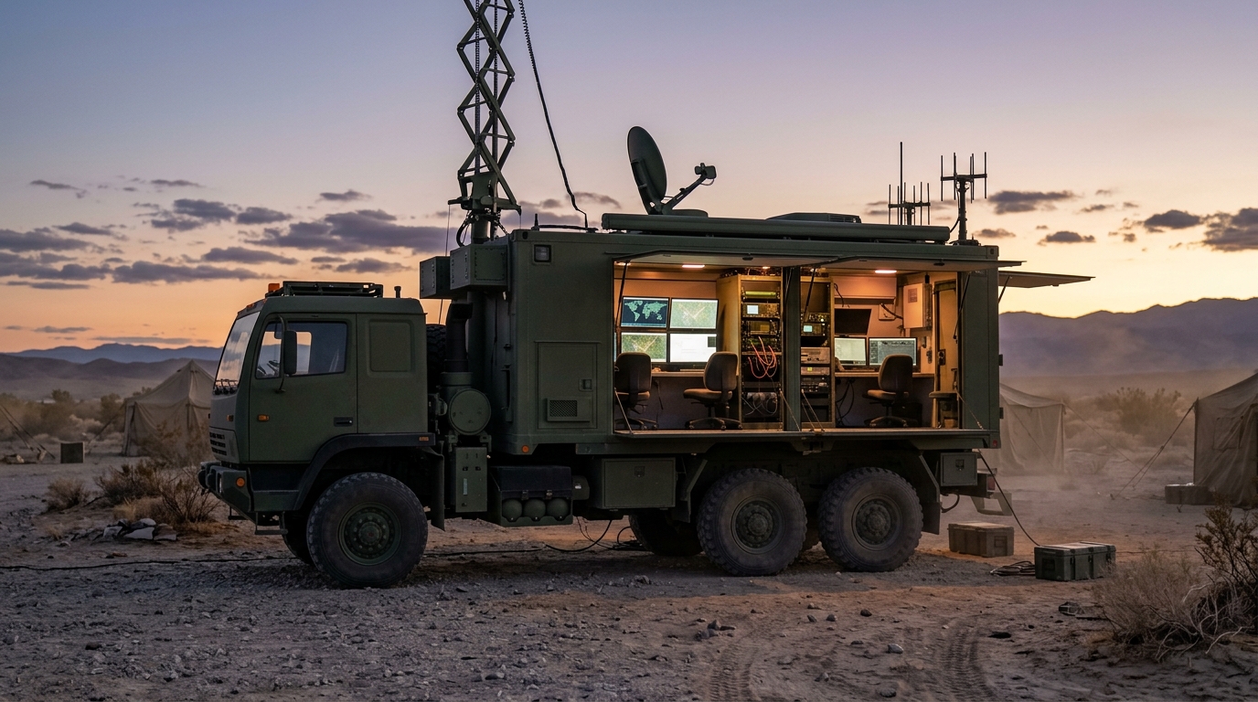
Portable command-and-control systems housed in ruggedized, vehicle-mounted shelters provide deployable command posts that replicate the essential functions of fixed centers. These mobile units incorporate workstations for displaying fused sensor data, communications equipment for coordinating with ground patrols and aerial assets, and satellite connectivity for maintaining links with higher headquarters and national command authorities. The ability to establish a fully functional command post at any location along the border within hours of a deployment decision enables responsive force management that is not possible from fixed facilities alone.
Satellite connectivity is the enabling technology for mobile command operations in desert environments. Because terrestrial telecommunications infrastructure is typically absent in border regions, all data exchange between mobile command posts, sensor networks, UAV platforms, and fixed command centers depends on satellite links. Modern very-small-aperture terminal systems provide sufficient bandwidth for real-time video, sensor data feeds, and voice communications from compact antenna packages that can be deployed and operational within minutes of arrival at a new location.
Rapid deployment is facilitated by modular system architectures that separate sensor, communication, and command components into individually transportable packages. A border surveillance response kit might include a mast-mounted thermal camera and radar on one vehicle, a communications relay package on a second vehicle, and a command shelter on a third. These components can be transported to any accessible location along the border, erected and networked within a few hours, and operated continuously for as long as the operational situation requires before being recovered and redeployed elsewhere.
Building Persistent Awareness Across Vast Frontiers
The fundamental objective of desert border surveillance is the creation of persistent awareness: a continuous, reliable understanding of activity along the entire frontier that enables security forces to detect, assess, and respond to threats before they achieve their objectives. Achieving this level of awareness across thousands of kilometers of harsh terrain is among the most demanding challenges in the security technology domain.
Success depends on the integration of the technologies discussed in this analysis into coherent surveillance architectures that are designed from the outset for the specific conditions of each border segment. There is no single technology solution. Thermal imaging provides exceptional nighttime detection but requires supplementation during daytime. Radar provides all-weather coverage but needs optical confirmation for classification. UAVs deliver flexible aerial surveillance but cannot be everywhere simultaneously. Ground sensor networks provide persistent presence but have limited classification capability without cueing from other sensors.
The synthesis of these capabilities through integrated command-and-control platforms, supported by robust communications networks and sustained by logistics chains designed for remote desert operations, creates a surveillance capability that is greater than the sum of its individual components. When a seismic sensor detects footfalls in a remote wadi at midnight, and a radar confirms a slow-moving target at the corresponding location, and a thermal camera on the nearest sensor tower acquires a heat signature consistent with a group of personnel, and a UAV is redirected to provide continuous overhead tracking while a response team is dispatched, the border surveillance system is functioning as designed: detecting, confirming, tracking, and enabling response in a continuous chain from first alert to resolution.
For nations across the GCC and Africa that face the challenge of securing extensive desert frontiers, investment in integrated surveillance technology is not merely a modernization initiative. It is a strategic imperative that directly supports sovereignty, public safety, and the ability to maintain control over national borders in some of the most challenging operational environments on Earth. The technologies exist, the architectures are proven, and the operational benefits are demonstrated. The task for defense and security planners is to deploy these capabilities at the scale and with the resilience that their borders demand.